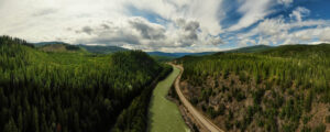
The 340 kilometres of paved highway from Kamloops to Tête Jaune Cache follows the route of the Overlanders of 1862, the first survey route for the Canadian Pacific Railway, and the present path of the Canadian National Railway. For most of its length, it follows the North Thompson River Valley with climatic zones varying from semi-desert at Kamloops to one of the province’s heaviest snowfall areas at Blue River. Traffic is generally much lighter than on the Trans-Canada Highway and the grades are less steep, making recreational vehicle travel less demanding on horsepower and nerves.
First Nations Trading Centre
Kamloops, the western junction of Yellowhead Highway 5 and the Trans-Canada Highway, has been the centre of trade in the Interior of British Columbia for more than 30 centuries. The Shuswap group of the Interior Salish peoples found the climate mild and the food plentiful. The characteristic depressions of their long-abandoned homes can still be seen in many places near Kamloops.
When traders from John Jacob Astor’s Pacific Fur Company discovered the First Nations settlement late in 1812, they were welcomed into the community. The Astorians established the first and only American fur trading post on what is now British Columbia soil. The American presence was short-lived, however, and the post was soon sold to the Montreal-based Northwest Fur Company, which later merged with the Hudson’s Bay Company.
Today, Kamloops is a modern sprawling city of close to 110,000 people. The fur trade has long slipped into oblivion, but remnants of the past cultures can still be found on display in the Kamloops Museum. Generally regarded as one of the best community museums in western Canada, the Kamloops Museum houses a superb collection of Salish baskets and artifacts, plus reminders of the people who followed the original fur traders into the Thompson district.
Transportation Hub
Kamloops is also the transportation hub with highways coming into it from all directions. From the junction of Yellowhead Highway 5 and the Trans-Canada Highway at what was once the east side of the city, the Yellowhead passes under the morning shadow of Mount Paul, and then heads north through the suburb centres of Rayleigh and Heffley Creek.
Sun Peaks Resort
Heffley Creek is also the junction point for a highway leading eastward to several popular fishing and boating lakes and the Sun Peaks Resort area. Heffley Lake and Little Heffley Lake are near the road, while side roads lead into several other interesting lakes. Sun Peaks, 45 minutes from the Kamloops city centre, is one of the most accessible major ski resorts in Canada. It boasts of a convivial atmosphere, ample accommodation, and a multitude of downhill ski runs to suit every taste and ability.
McLure Reaction Ferry
North Thompson River crossings are limited north of the bridges in Kamloops. The McLure Ferry, 43 kilometres north of the city, is one of BC’s fleet of free inland ferries. It can carry two vehicles and a dozen passengers and operates on-demand between 7:00 am and 6:20 pm, with a lunch break from noon to 1:00 pm. If you are interested in doing a bit of exploring, you could cross on the ferry and return to Kamloops or continue north to Barrière on the west side of the river.
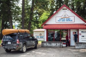 Gearing up for a fishing trip at the historic fly shop in Little Fort.
Adams Lake—Shuswap Lakes Loop
Louis Creek, 14 kilometres north of McLure, is the gateway to Adams Lake and the network of big lakes that lie snuggled up against the Monashee Mountains. Agate Bay Road to Adams Lake is paved, but the rest of the roads in the area are busy gravel logging roads. There are several BC recreation sites on Adams Lake.
Spawned by a Gold Rush
While snow may be the source of gold “in them ‘thar’ hills” today, many historians suggest that it was the discovery of gold in the tributaries of the Thompson River that triggered the rush that swept through southern British Columbia in the 1850s. Although not as rich as the bars of the Cariboo, the North Thompson and its tributaries did cause some excitement. While “Doc” Keithley was taking $75 pans out of a Cariboo creek that bears his name, François Lavieur and his compatriots were working the Barrière River, 65 kilometres north of Kamloops and making $50 per day. Gold was worth about $16 per ounce then, but with the present prices reaching 125 times that amount, it could make panning for the gold that Lavieur overlooked worthwhile.
Rainbow Trout
It is the rainbow trout, rather than the gold at the end of the rainbow, that interests many of today’s vacationing travellers as the Barrière area offers ample fishing opportunities. Gravel roads lead east into the headwaters of the Barrière River and the North, East and South Barrière lakes. British Columbia recreational campsites are located at all three lakes and privately operated fishing camps are located on East and North Barrière Lakes.
The Yellowhead Highway crosses to the west side of the North Thompson, just north of Barrière. If you prefer to explore the backcountry, you could wind through town and follow Dunn Lake Road north to Little Fort or Clearwater along the east side of the North Thompson.
To the west of the town of Barrière lies the Bonaparte plateau with dozens of fine fishing lakes, several of which have public camping facilities.
HBC Outpost
Little Fort, 29 kilometres north of Barrière, is named so because it served as a Hudson’s Bay Company outpost for the fur trade from 1850 to 1852. It is the junction of Yellowhead Highway 5 and 98-kilometre-long Highway 24, linking the North Thompson Valley with the Cariboo Highway at 93 Mile House. It passes through a recreational area well worth visiting. Dozens of campsites and fishing camps located on cool, clear plateau lakes await those who are willing to venture off the main highways in the summer. In the winter, many of the same fishing camps open their lodges to cross-country skiers, snowmobilers and ice-fishers. Lac des Roches and Bridge Lake are two of the larger lakes in the area, while Mahood Lake and the westernmost portion of Wells Gray Provincial Park are also accessible off Highway 24.
Little Fort is also the site of one of British Columbia’s few remaining current-powered river ferries. The Little Fort ferry also operates from 7:00 am to 6:20 pm, serving the needs of local ranchers and providing access to some excellent fishing holes on the east side of the river.
Gateway to Wells Gray Park
Thirty kilometres north of Little Fort, the Yellowhead Highway 5 passes through the village of Clearwater. If you are looking for a break, there is a BC Parks campground near the North Thompson River just south of Clearwater and a commercial campground at nearby Dutch Lake, just west of the main crossroads.
If you are interested in exploring the backroads, Clearwater River Road follows the Clearwater River upstream along the bottom of the canyon. Landslides have limited access, but if you don’t mind getting a bit damp, Interior Whitewater Expeditions offers a variety of trips on the Clearwater River.
Traffic Circle
At the time of writing, the only traffic circle on the Yellowhead Highway was at the north end of Clearwater. The road to the right heads to a school and shopping centre. Clearwater Valley Road heads left (north) to the main entrance of Wells Gray Provincial Park.
The Clearwater Visitor Centre, just north of the junction, is a good place to stop for maps and advice before heading into the wilderness. It is worth noting that the service stations near the junction are your last chances to fuel up.
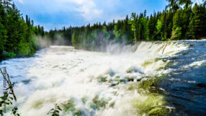
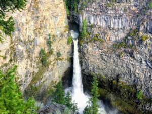
Wilderness and Waterfalls
Wells Gray Park is the ideal vacationland for the camper, hiker, backpacker and canoeist who want to enjoy the wilderness atmosphere without chartering a safari to Africa or the Arctic tundra. Although there are fully serviced campsites, motels and hotels in and near Clearwater and along Clearwater Valley Road, a.k.a. Wells Gray Road, the BC Parks campsites in Wells Gray Park and North Thompson Park are not equipped with RV hookups. Instead, each unit has a parking spur, tenting space, fireplace and access to water, wood and a community outhouse. Reservations are accepted online for a number of the campsites.
Wells Gray Park is truly a waterfall park. Helmcken Falls, which drops more than 140 metres in a single plunge, is the star attraction of the park. For diversity, the 541,500-hectare park also contains five major lakes; two large river systems; numerous small lakes, streams and waterways; plus a multitude of waterfalls, cataracts and rapids. It also contains young volcanic lava beds, un-named glaciers and snow-capped mountain peaks, mineral springs and plenty of well-marked trails—used in the summer by hikers and in the winter by cross-country skiers.
If you aren’t up to serious canoeing or kayaking, Clearwater Lake Tours offers boat tours on Clearwater and Azure lakes during the summer months. They have a base at the Clearwater Lake campsite, 68 kilometres north of Yellowhead Highway 5.
A point well worth mentioning is that the rivers of the area are wild and treacherous and are best observed from a firm footing on the shore. They have claimed many lives, as have the larger lakes, and should be treated with respect.
STATISTICS
Distance: 125 km: Kamloops to Clearwater.
Travel Time: One to two hours plus distractions.
Communities: Kamloops, Barrière, Clearwater, Blue River, Valemount.
Additional Resources:
Backroads Mapbook: Thompson Okanagan BC
BC Parks: bcparks.ca
BC Recreation Sites & Trails: sitesandtrailsbc.ca
Clearwater Lake Tours: clearwaterlaketours.com
Interior Whitewater Expeditions: interiorwhitewater.com
