Vancouver Island
- Sooke Potholes
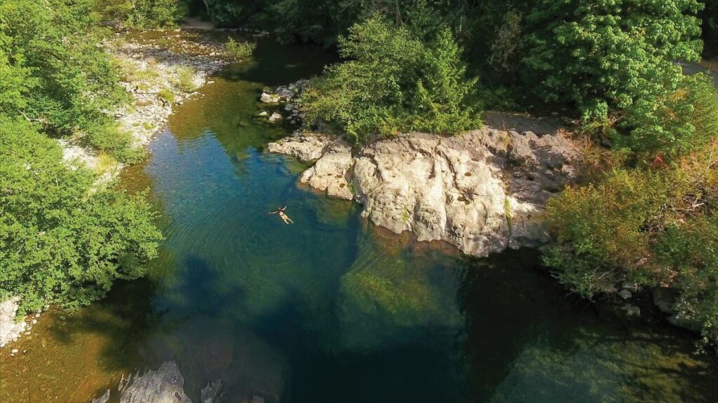
Sooke
One trip to Sooke Potholes Provincial Park and you’ll see why this is such a popular destination for south islanders. The tall cedars and salmon swimming in the river give this swimming hole a wild vibe but you’re not too far from civilization. The naturally formed, polished rock pools were created during the last ice age, 15,000 years ago, when the melting icepacks carved deep trenches in the bedrock and carried huge boulders that became lodged and helped form the potholes through erosion. Today these pools are filled with crystal clear water from the Sooke River as it flows to the ocean.
The park is day-use only, so you’ll have to arrange for accommodations elsewhere, such as at Spring Salmon Place (KWL-UCHUN) Campground or Sooke Potholes Campground, which are both located to the north of the park. The Sooke Potholes also features several great hiking trails and are adjacent to the Galloping Goose Regional Trail, which is a popular route for biking and hiking.
- Cathedral Grove
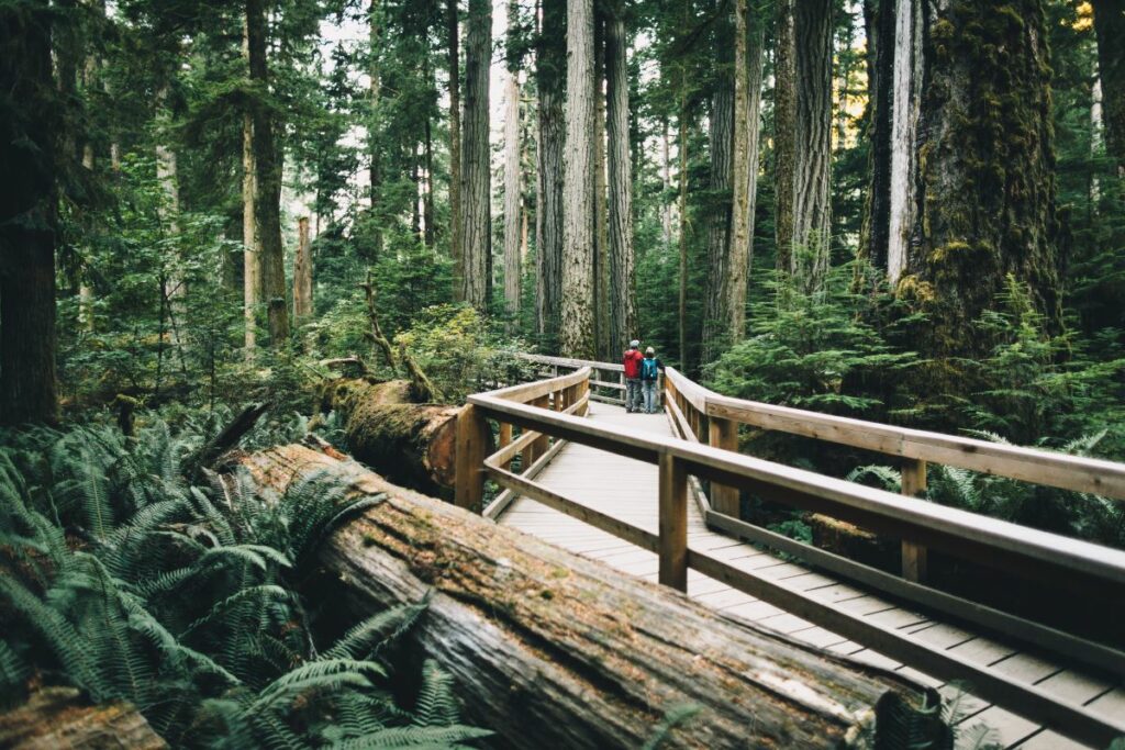
MacMillan Provincial Park
Cathedral Grove, located in MacMillan Provincial Park on Vancouver Island, is one of the most accessible stands of giant douglas-fir trees in the province, and the towering giants are sure to inspire awe: the largest trees in the park are 800 years old and over 75 metres tall. Other species in the park include western redcedar, bigleaf maple, western hemlock and grand fir, making this a nature-lover’s paradise.
The park straddles Highway 4 and you’ll find the largest douglas-firs on the south side of the highway including one that measures almost nine metres in circumference. A trail system meanders through the trees and you can spend an hour admiring their majestic beauty as you amble through the forest. You’ll drive through Cathedral Grove on your way to Tofino or Ucluelet and it’s the perfect place to build stoke for your West Coast adventure.
COAST & MOUNTAINS
- Old Alexandra Bridge
Alexandra Bridge Provincial Park
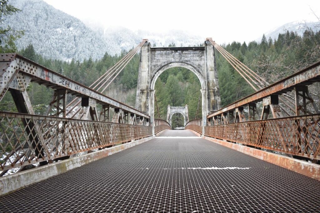
Finding the old Alexandra Bridge, through the trees and over the tracks, is like walking into the past. If you are travelling along the Trans-Canada near Spuzzum (between Yale and Boston Bar) and need a rest stop, a place to picnic or the perfect backdrop for a family photo, this is it.
Now Alexandra Bridge Provincial Park, this area of the Fraser River has been inhabited by First Nations for thousands of years. Europeans first visited in the early 1800s when Simon Fraser’s expedition stumbled upon the area, and it became a popular route north during the Gold Rush.
Today, the half-kilometre walk to the bridge takes less than 10 minutes and is fairly accessible following the abandoned Cariboo Wagon Road. Considered a feat of engineering in the 1800s, builders blasted footings out of the hills alongside the Fraser and Thompson rivers and carved the road from Fort Yale to Barkerville’s gold using picks and shovels. If you look closely, you will see the footings of the original bridge, built in 1861, which was torn down in 1912 and replaced in 1926 by the dilapidated crossing that stands today.
On your way down, peek through the rows of western hemlock, redcedar and douglas-fir to the modern Alexandra Bridge along Highway 1. Be careful crossing the railroad tracks that are still in operation, and if you’re afraid of heights, don’t look down through the bridge’s metal-grate floor to the river rushing below. For a bit more adventure before buckling-up again, cross the bridge and see if you can find the deserted cabin and cars where the forgotten highway is lost to the forest.
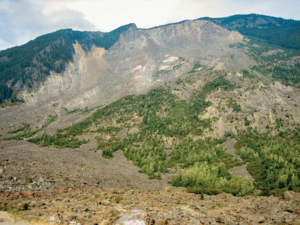
- Hope Slide
Hope
Driving by, it appears to be a typical mountain. The Hope Slide, in the Cascade Mountains’ Nicolum Valley is a piece of BC history that changed the landscape and claimed four lives. On January 9, 1965, an earthquake triggered the mountain to give way causing the second-largest landslide in Canadian history. In a matter of seconds more than 46 million cubic metres of rock, earth and snow came rolling down the mountain like a tsunami, filling up the valley and obliterating Outram Lake.
Travelling to and from the interior, there is a viewpoint on Highway 3 that allows people to park and read about the catastrophe. The site now serves as a memorial of sorts, to experience first-hand the powerful force of nature that took place, with the remnants of gigantic boulders strewn every which way.
The parking lot is located on the edge of the rubble zone, built on the slide debris, approximately 55 metres above the original ground.
Thompson / Okanagan
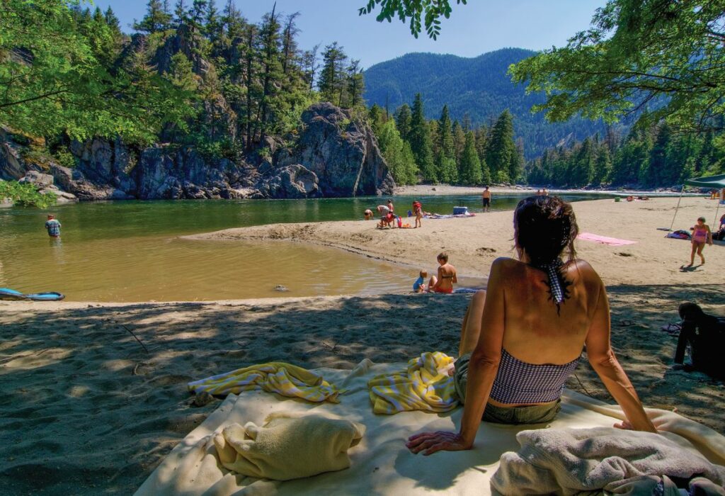
- Bromley Rock
Provincial Park
Similkameen Valley
This park is small, but the fine sand beach, calm swimming pool and high rocky bluffs make up for the lack of size. In the summer, when the water level of the Similkameen River is lower, the rocky bluff provides a back eddy and a calm pool perfect for swimming. This is easily one of the best swimming holes in the area. The sandy beach is great for family picnics and catching some rays after taking a dip. Tubing and floating are also popular on the Similkameen River, with a downstream route that leads to Stemwinder Provincial Park.
Located four hours from Vancouver along Highways 1 and 3, this area is a perfect first stop for car campers travelling to the Kootenays and beyond. The excellent provincial campsites at Bromley Rock and Stemwinder parks are easy to book online, and their proximity to the Similkameen River makes for great toe soaking at the end of a day’s drive. As you continue on your trip, make sure to plan for a stop at one of the fruit stands in the Keremeos area. Pro tip: you can find great Indian food at some of the fruit stand restaurants.
Kootenay / ROCKIES
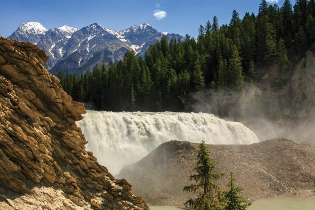
- Wapta Falls
Yoho National Park
You’ll find this short hike just a 20-minute drive from the town of Golden, along the Trans-Canada Highway. You’ll also find it offers quite possibly the most impressive view on any hike less than five kilometres in the whole province. Park at the trailhead, where you’ll find washrooms and a picnic site, then follow a well-marked, mostly flat 2.4-kilometre trail toward Wapta Falls. You’ll wander through short evergreens, eventually hearing the roar of the Kicking Horse River as it drops 30 metres to form Wapta’s cascade. Your first view will be from above—in spring, the torrent is a misty, soaking thunderous cascade of raw, impressive power. Follow the steepening trail around the lower lookout—you’ll likely start to get damp—and revel in a view of Chancellor Peak beyond as spray from the falls creates a rainbow above the alluvial flats formed in its wake. Return the way you came.
For a special treat, road-trip this way in winter. Yoho is an unserviced park between October and May, so you’ll have to snowshoe in from the highway—making the distance around nine kilometres return—but you’ll have the opportunity to get up close and personal with the ice-castles formed by Wapta’s frozen torrents.
CARIBOO / CHILCOTIN
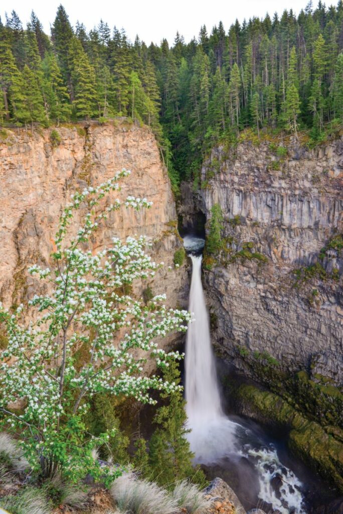
- Spahats Falls
Wells Gray Provincial Park
Spahats Falls, located on the edge of Wells Gray Provincial Park, isn’t the most famous or the largest waterfall in the park—the park is home to 39 falls, including the legendary Helmcken Falls—but there are two reasons not to miss it. First, it’s easy to get to. The parking lot and trailhead is located about 10 kilometres north of Clearwater and the trail is an easy one-kilometre meandering affair that winds its way through magnificent fir trees. The sound of the falls echoes through the forest, building an excitement that will quicken your pace as you near the balconies that overlook the falls.
Once you arrive, the view that opens up is spectacular; a horseshoe-shaped canyon with a powerful waterfall cutting deep into its walls. This jaw-dropping formation is made from deposits of volcanic rock in the Wells Gray-Clearwater volcanic field. It’s estimated the falls are around 60 metres tall, but when including the second tier, it is closer to 80 metres tall.
The second reason why this is a must-stop is to grab a hot coffee and freshly made Belgian waffle from the locally acclaimed food cart that is located at the trailhead carpark. The parking lot is located 10.3 kilometres from the Wells Gray Information Centre.
NORTHERN BC
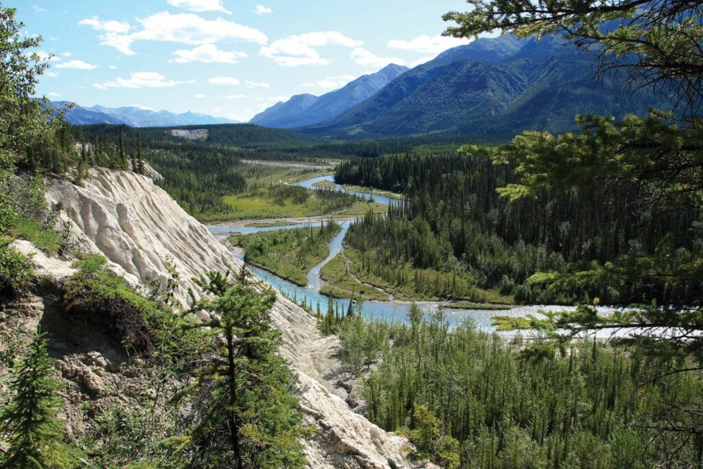
- Mineral Licks Trail
Muncho Lake Provincial Park
Northwest of Fort Nelson, on the way to Yukon, BC’s portion of the Alaska Highway passes through one of the great scenic wonders of the world—Muncho Lake Provincial Park. Dense boreal forest. Waves of mountain peaks. Emerald lakewater, fed by ancient glaciers. The 12-kilometre long namesake lake is rife with lake trout and Arctic grayling. And stone sheep make such regular appearances drivers need to slow down and keep watch for these great horned bullies of the mountains. Think Jasper National Park, without the crowds.
Muncho Lake Provincial Park is vast and rugged. For the road-tripper though, Mineral Licks Trail offers a good glimpse into this verdant ecosystem without much commitment. At just 1.3 kilometres long, and accessible right off kilometre 731 of the Alaska Highway, this loop offers two gorgeous viewpoints as it meanders along the Trout River to the pasty Mineral Licks cliffs. This nutrient-rich area attracts wildlife, which, as you might imagine, lick for the minerals stored in the soils. So steer clear of mammals who use the area as a respite. The trail can be slick in the rain, and some cliffs are exposed. But in less than an hour’s walk, your appetite for adventure will be whet—and you’ll be planning next year’s multi-day epic into this Northern Rockies wonder.