
Enjoying a campfire on a secluded lake at the end of a long day of adventure is one of life’s great pleasures, and not something that comes easily in the southwest corner of British Columbia. Like most things worthwhile, the art of finding a beautiful campsite follows the old pick-two-out-of-three rule—it can be close, easy to get to or free from crowds, but not all at once. There is a valley, however, 300 kilometres north of Vancouver that comes about as close as you can get to offering all three, so long as you’re a little flexible on your definitions of close and easy.
Last September, a friend and I were looking for a three-day backroad adventure that took us beyond the busy forest service roads in the Sea-to-Sky Corridor. We had spent several years exploring the routes to places like Indian Arm or the Elaho Valley, but we wanted to go farther while seeing more history and fewer people. So naturally, we set our sights north.
The Bridge River Valley lies just north of Pemberton and 100 kilometres west from Lillooet. It is truly off-the-beaten-path and not an easy route to anywhere. It doesn’t have what most would consider “famous sites” or “tourist amenities” (or even cell service), but it does offer open wilderness and a history that’s on the roadside just waiting to be discovered.
The valley can be accessed from the east through Lillooet or from the south through Pemberton. The easier Lillooet route offers year-round access from Highways 1 and 12 through Hope and Lytton, or the Duffey Lake Road / Highway 99 route through Pemberton. From Lillooet, you drive west along Lillooet Pioneer Road 40, which is a mix of paved and gravel surfaces that takes you right along Carpenter Lake Reservoir, which is spectacular. It takes roughly four hours to drive from Vancouver to Lillooet on either approach, then another two hours to get to Gold Bridge.
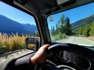
The quicker, more direct, and shall I say more fun route is north from Pemberton along the Pemberton Meadows Road and the infamous Hurley River Road. This route connects the Pemberton Valley to the Bridge River Valley and is entirely rough dirt and gravel with washboards and the occasional washout. It is accessible only in the summer with a reasonably capable four-wheel drive vehicle. To drive the point further home, you can visit isurvivedthehurley.com for current conditions and to get a taste of what you’re in for.
We, of course, chose to take the Hurley. Wanting to maximize our daylight exploration along the Hurley and in the valley, we drove up to Pemberton on Friday night after work, where we stocked up on provisions and camped at Nairn Falls Provincial Park. With an early start on Saturday morning—wanting to time our arrival in Bralorne for a lunchtime beer at the pub—we aired down our tires as soon as we hit gravel to help smooth out the bumps. Having an air compressor on board and dropping your tire pressure to 20 to 25 PSI can make backroad adventures much more comfortable.
Another backroad essential is a good map / app like the Backroads Mapbook or Gaia GPS, and a walkie talkie to communicate between vehicles. This allowed us to not only avoid getting lost, but to identify potential sites of interest like lakes, old mines and abandoned cabins—we didn’t want to miss them in the dust.
The Bridge River Valley has a long history dating back to the late 1800s when gold prospectors travelled up from the Fraser River looking for the source, or mother lode, of all the gold they found downstream. And find it they did, with mining towns like Gold Bridge, Bralorne, Minto and Bradian popping up to support the thousands of miners and prospectors that worked the mine sites through the first half of the 20th Century.
The Bralorne and Pioneer mine sites were some of Canada’s largest, with more than four million ounces of gold coming out of the valley before the last big mine in Bralorne closed in 1971. Today, there is a reactivated gold mill at Bralorne that employs 50 people, and around 200 people live in the valley year-round.
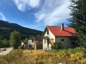
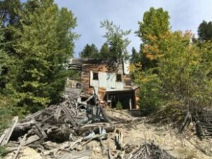
Most of these sites and towns are either abandoned or destroyed and offer explorers a chance to revisit the past. Of particular interest for us was the ghost town of Bradian (which lies close to Bralorne and is currently for sale) and the old Pioneer Mine. We spent a couple hours exploring these sites and the surrounding areas. Here, we saw long-abandoned houses, and the twisted remains of a gold mine that was both dismantled and burned, leaving our imaginations to fill in what it must have looked like in its heyday. There is also the Bralorne Pioneer Museum and Haylmore Heritage Site for those who want more of a structured history lesson, and to see old photos of these sites and historical artifacts. Both of these museums are fascinating and staffed by knowledgeable and interesting locals.
If you do choose to explore some abandoned sites, be cautious and make sure to look for and obey “caution” and “no trespassing” signs. While you’re unlikely to find gold nuggets just sitting around, keep an eye out for jade cobbles in roadside rubble and stream beds. We found some nice pieces of nephrite jade when we stopped to let the dog out for a walk.
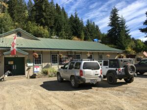
With our exploration done for the day, it was time to find a place to spend the night. There are motels and pubs in both Gold Bridge and Bralorne, as well as small stores where you can find memorabilia and limited supplies. We decided to do our research at the Bralorne Pub, where we enjoyed perhaps the most refreshing beer of our lives while playing pool, looking at the pictures and maps on the walls and talking to the lovely bartender. We were too early to try their hand-made pizzas for dinner, but we got some great recommendations on where to camp for the night from some friendly locals.
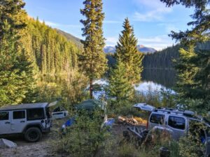
We ended up staying at Kingdom Lake, where we had the entire place to ourselves with a lake-side campsite, small dock for fishing and a beautiful view of the sunset. There are several other recreational sites in the area, including Gun Lake, Gwyneth Lake and Mowson Pond. We went in late season, so we had our pick of spots, but things certainly get busier during the summer. Still, compared to the campsites closer to the city and not at the end of a bumpy dirt road, your chances of finding a memorable site are much better.
If you and your vehicle are up for it, the Bridge River Valley offers days of wilderness backroad adventures. The rivers, valleys and forests are stunning, and the climate is dryer and warmer than the coast. If you’re coming up from the south, it truly feels and looks like you are at the gateway to the Chilcotin. And it just gets better with the more exploring you do and the more locals you talk to.
When You Go
