On a summer day in 1995, John Harper, a BC marine geologist, realized there was something he was repeatedly seeing from his vantage point in a low- and slow-flying helicopter that made no sense. In the previous years—following the 1989 Exxon Valdez accident that spread 41 million litres of oil along 2,200 kilometres of Alaskan coastline—he’d been hired to do aerial photographing of the state’s coast in order to provide authorities with spill-related contingency data. Following two subsequent BC oil spills, he’d begun—under the auspices of a research project called ShoreZone—doing the same thing here.
Flying during the lowest summer tides, he’d seen exquisite BC estuaries etched with meandering streams. He’d seen parallel, shoreline biobands, marked by distinctive, colourful species as each organism found its place within the varying depths of the tidal zone. He’d seen First Nations’ shell middens, rock-free canoe runs and fish traps. But he realized on that day a strange feature kept reappearing in his camera. Above Tracey Island, one of hundreds that dot the Broughton Archipelago on the province’s mid-coast, Harper began to realize that something… or someone had created a lot of low, boulder-cobbled walls along the archipelago’s shallow bays, exactly at the point where the lowest tides stopped. They were everywhere. They didn’t appear natural. He stopped counting at 350. “I can’t figure out what that’s due to,” he said to his airborne research companions.
It would take him eight years to solve the mystery.
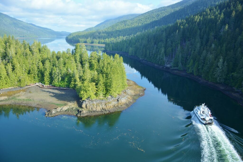
Over the past decades, the ShoreZone survey has collected extremely low-level aerial photography of virtually every metre of the 110,000-kilometre coast of northwestern North America. From high-Arctic Alaska to southern Oregon, these 500,000 photographs provide a never-before-seen, close-up, GPS-specific, free-to-the-public inventory of things previously unknown or unmeasured. What started as a mapping project to identify sites vulnerable to marine oil spills has, however, expanded into something much more ambitious. First Nations look at ShoreZone’s bird’s-eye images of BC’s northern coast and realize they are seeing massive shell middens, indicative of possible, long-abandoned village locations. Recreational kayakers and outdoor adventure companies can identify remote islets and headlands, suitable for wilderness campsites. Hazard specialists can pinpoint locations vulnerable to Pacific tsunamis. Marine biologists can identify places where important shoreline eelgrass or shellfish habitat would be threatened by industrial pollution or port developments. And Harper could—as he did in time—come to understand what the strange, low-tide boulder walls were for.
In recent decades, Mary Morris, an intertidal marine biologist, has regularly ridden the ShoreZone helicopters. She usually sits next to the pilot and in front of Harper, who is securely harnessed because his door is off, while a navigator sits next to Harper keeping track of the helicopter’s flight path and GPS positions. Even with noise-reducing earmuffs, the chopper’s rotor-clatter is intense. Microphones are the only way to communicate. While Harper films, Morris takes still photographs and keeps a running biological commentary, her audio synchronized to his video of what’s passing beneath. Flying without a door, regardless of outside temperatures, produces cold 120 km/h winds. Low-level flying also produces dramatic—even vertiginous—views straight down 100 metres to the passing rocks and surf below. It’s not a task for the faint of heart.
Despite being thrilled by aerial views of BC’s coast, Morris’s preference, understandable for a biologist, is to be mucking around on the ground. “British Columbia has one of the richest and most diverse coastal marine systems in the world,” she says. “Flying’s torture for me! About a billion times I see things below and I want to jump out! I want to inhale the smell—like iodine—of low tide. The eagles feasting. The algae-covered rocks, the kelp, the seaweed, the surf-grass—all so slippery. I want to roll in it. Sometimes…” and her voice drops confessionally: “I do.”
With Morris’s focus on coastal biology, ShoreZone’s earlier mapping goals have shifted toward the scientific uses of the data gathered. Today, environmentalists, climate-change researchers and policy planners can turn to the detailed biological data and GPS-linked coastal images and know exactly what is where. Where is hard, bedrock shoreline? Where are the soft places: the mudflats where shellfish live; the marshes and estuary seagrasses vital to young fish? (After the Exxon Valdez disaster, emergency clean-up workers failed to focus sufficiently on the soft places, vital to intertidal marine life. Today, 30 years later, a shovel pushed into Alaska’s Prince William Sound salt marshes hits oily sediments 20 centimetres down.)
Says Morris of the dangers coastlines face, “Action always happens at the edges—where competing forces meet. There’s a thread of marine creatures that inhabit tidal zones, each adapted to a specific amount of daily saltwater submergence, air exposure and sunlight. But unlike terrestrial animals, a lot of them can’t move. So… sediments and pollution from industries, port expansions, rising sea levels, warming oceans… the shellfish are stuck. They’re there. They can’t run away.”
Working with Burrard Inlet’s Tsleil-Wautuh Nation, researcher Lindsey Ogston is using ShoreZone data and images to determine what long-term impacts have occurred along Greater Vancouver’s most industrialized shoreline, and what actions are needed to rectify things. For millennia, local First Nations used the inlet for its marine food sources: herring, clams, mussels and oysters. But today, the herring are gone. And inlet’s shellfish are toxic. Says Ogston: “There are things we can do—a lot of little actions—that can build toward long-term changes to protect and restore the shoreline habitat.” And she uses North Vancouver’s Maplewood Mudflats, located east of the Second Narrows Bridge, as an example. This salt-marsh and eelgrass shoreline was once a valuable First Nation’s food source. By comparing historic photographs of the mudflats to those made during a 2017 ShoreZone aerial survey, it’s clear that debris, pollution and nearby industrial developments need to be contained if the area is to be returned to a healthy habitat.
Similarly, federal fisheries’ biologist James Mortimer and Port of Prince Rupert’s environmental manager, Jason Scheer, both use ShoreZone images and data to help plan for shoreline contingencies like the consequences of LNG pipeline construction in northern BC and increased shipping traffic near Prince Rupert where tonnage is predicted to double by 2050. “If you don’t know where the vulnerable places are,” says Mortimer, “you can’t plan for protection and mitigation if something happens.”
In recent years, marine biologist Sarah Cook has assumed overall administration of ShoreZone aerial surveys and the GPS-specific mapping. Sixty different entities—from various levels of governments to industrial interests—now fund the project. This includes covering the cost of $1,500-an-hour helicopter flights whenever weather and summer’s lowest tides synchronize. Drawn initially to marine biology by the discovery of the Titanic wreck and the mysteries of the ocean bottom, Cook now spends much of her time airborne, looking down on the shallowest of seawater, snapping photographs every three to five seconds and recording the biological data she observes. Seen from above, experience has taught her—from texture and colour—exactly what lies along the splash-zone below: the greens of mid-beach algae, the beige of exposed barnacles, the golden brown of rock weed, the blacks of lichen, the lime-green of water-loving eelgrass, the shiny browns of half-submerged kelp. Each narrow segment of intertidal zone has, too, its marine creatures—its blue mussels and cream-coloured clams—that together form a sort of linear, earth-toned rainbow of shoreline biobands.
Some days she sees bald eagles and scavenging bears. And on other days the remnants of ancient First Nations’ occupation that hint at how widespread native settlement was along BC’s coast—before 19th century diseases decimated the province’s coastal societies.
As the years passed, John Harper became increasingly obsessed by the hundreds of mysterious walls that marked the lowest tide-line, and the vast number of debris middens he was filming for ShoreZone. Every mid-coast island had six to eight middens. On closer inspection, some were 10 metres deep in places and full of whalebones, shells and charcoal, indicating a lengthy native occupation. Archeologists dated the oldest debris samples to 2,000 years ago. But no one could explain what to make of the bizarre boulder walls he’d discovered.
Harper’s first clue came from the legendary fisherman-beachcomber-author Billy Proctor of Broughton Archipelago’s Echo Bay. He told Harper that he’d heard the natives called them “clam terraces.” The walls, he explained, helped them farm the ocean’s shoreline. It took more time to learn from the late Kwakwaka’wakw clan chief Adam Dick how—over past millennia—coastal natives developed a unique system of extracting and then rolling hundreds of thousands of basketball-sized intertidal boulders to the very edge of the lowest tide. Butter clams were then “planted” within the boulders’ holes. As the incoming tide flowed through the rock walls’ perforations, it inundated the low-lying shoreline with ocean sediments. Then, as the tide slowly ebbed, it left behind—day by day, year by year, century by century—nutrient-rich silt that nourished the trapped clams. “This knowledge was handed down,” said Dick, “through the generations. The clam gardens fed us in winter. They helped us populate the coast here. No one does it anymore.” Using radiocarbon dating, scientists investigating the clam gardens today suspect that smallpox epidemics, which depopulated the BC coast over 150 years ago, gradually led to the abandonment of native village sites, including the middens and clam gardens.
None of this was known to 44-year-old William Nelson who grew up amid BC’s northern Tsimshian culture: living within the natural rhythms of the seasons; his family gathering berries and fishing; his father wood carving. When Nelson got a job in 2014 working with the Metlakatla Nation, traditional occupants of the coastal region west of Prince Rupert, John Harper appeared one day. He was full of excitement, carrying with him ShoreZone video footage of the hundreds of abandoned clam gardens he’d found 500 kilometres to the south. Harper wondered if the Metlakatla had had clam gardens, too. Says Nelson: “It was entirely new to me! I’d never heard of clam gardens. No one had. It made me realize how much of our culture has been lost.”
So, with Metlakatla Stewardship Society funding and ShoreZone imagery, Nelson set out to explore the past. As he watched and re-watched the aerial ShoreZone videos of Metlakatla territory, he began seeing evidence of long-lost village sites, and examples of the First Nations coastal terraforming of the land. There were charcoal-filled middens washing into the sea, and—with Harper’s help—they identified 55 clam gardens where none were known before. “There’s so much to be discovered,” says Nelson today. “It’s really hard to see a lot of things when you’re on the ground. Patterns aren’t obvious: the house pits, the fish traps, the canoe runs. The aerial images show where the Metlakatla lived. It gives us a new perspective, a new sense of pride. It helps in our treaty claims. And our wish to protect the coast—to develop things like marine response plans to oil contamination. People were unaware our ancestors lived on the coast for a long time—maybe as long as 10,000 years. The Metlakatla can be stewards again, managing the water and the land… like they did before.”
How To Access ShoreZone
- Go to: com
- Under View the Images click See More.
- Click link Access BC ShoreZone Imagery and Mapping here.
- Use the + and – buttons in upper corner to zoom in on map section of interest.
- Zoom way in until the blue line becomes a series of blue and red dots.
- The blue indicates video; the red indicates still images.
- Click on the dots to view the image or video.
