
The rain comes down fast as the sun sets and we drive to our campsite. We planned our roof-top camping trip months ago but as the weekend approached, our idyllic vision of camping in the late summer heat washed away with the rainfall warning. We’ve camped in fall before, and it was gloriously warm, dry and free of the summer crowds. Fall weather on the BC coast is unreliable at best, and now we realize that we’re too late in the season. Resigned to our fate, we arrive at Owl Creek near Pemberton, a first-come-first-served site beside a Salmon bearing river. A “Bear in the Area” sign welcomes us in.
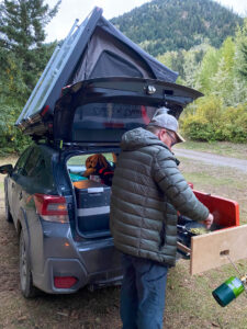
Pemberton is a short 20 minutes away from Whistler, or about two hours from Vancouver. The village is rugged, storied and authentic. The place and people feel real and despite its proximity to the world-famous Whistler, it feels undiscovered. It is our hidden gem and we’ve been planning our return all summer. Joshua placed the winning bid on a two day and three-night rental of an SUV outfitted with a roof-top tent, a battery-powered mini-fridge and a pull-out kitchen. This is our first experience camping with a rig like this after enviously eyeing them for years.
Rain jackets and headlamps are donned as we set up camp. Luckily, it’s quick. As I prepare my hot water bottle two other vehicles arrive and I start to feel less nervous about the bears. We make a simple camp meal and head to bed.
The earth exhales deeply sending up a dewy morning fog. We survived the night. Coffee percolates and we’re on our way. Let the adventure begin.
Semaphore Lakes is our feature activity for the trip, a popular hike in the summer with friends who have 4x4s. It features a meadow with a chain of three pristine alpine lakes—a lovely day hike or base camp for those adventurous enough to carry on up the mountains nearby. I imagine us to be these people, heading up to Locomotive Mountain. A 14.2-kilometre hike with a respectable 1,140 metres of elevation gain and spectacular views of the surrounding Railroad Group of the Coast Mountains. Getting to the trailhead is a chore. First, you pass through Pemberton meadows and then head up the Hurley River Forest Service Road.
The meadows are soggy and rain clouds hang over the farms dotted along the road. The farm stands that welcome slow food enthusiasts, road cyclists and tourists are mostly closed, sold out of the summer harvest. The one we visit is mostly leeks, onions and squash—I stock up on all of them even though there is no room in the fridge.
Turning right, we leave civilization and pavement behind. Our intestines rattle as we slowly roll over the pot-holed gravel. At first, Joshua tries to dodge them, but it is so rutted it is impossible. Can we last two more hours of this I wonder? Soon we see the Hurley River Forest Service Road sign and the switchbacks begin. Mercifully the road smooths out, a hint of sunshine pokes through and we think, “this isn’t so bad.” We glimpse spectacular mountain views as the rain and clouds fidget in the sky.
The Hurley River Forest Service Road is locally known simply as the Hurley and is a road generally reserved for those with a capable vehicle. The 74-kilometre logging road connects Pemberton to the town of Gold Bridge in the Bridge River Valley. For those not employed in the forestry industry, it provides access to some of the gnarliest explorations in BC and serves as a jumping-off point for multi-day mountain biking excursions in the Chilcotin Mountains in the summer and deluxe heli-skiing in the winter.
Open only in the summer months, the Hurley can be used as a long detour route to Lillooet. Most opt for Highway 99’s paved route, but they are missing out on the pride one gains from conquering the rugged drive. Strangers passing wave or give a manly “ya bro” nod, and Joshua is proud that we are conquering this road. He even jokes about starting an ‘I survived the Hurley’ club complete with bumper stickers and a T-shirt. Six months later I discover such a club already exists and they have trucker hats and regular reporting on road conditions. Unfortunately, they don’t ship—you actually have to drive the Hurley to get the merch. That’s next-level brand preservation and I respect it.
Driving the Hurley is awe-inspiring. When you can manage to unglue your eyes from the deeply rutted road you are rewarded with expansive views of mountain ranges and candy-coloured lakes and rivers. It’s a feast for the eyes and I’m glad we’ve come.
Rounding another switchback, a baby black bear tumbles down the mountainside onto the road. Oblivious to our existence, it saunters along before disappearing down the other side of a stream. Where is mamma bear, we wonder? We are a good drive away from our hike so I’m not worried and it’s not the black bear that makes me nervous, it’s the grizzly. I’m confident we can manage any black bears. Grizzlies are entirely different—they aren’t afraid or curious, just hungry, territorial and very large. Even with our bear spray and air horn, if we came face to face with a grizzly it would be a bad scene. What are the odds? September in BC is one of the final fattening up months before hibernation and our destination was described to me as a “grizzly highway,” so the odds are not as good as I’d like. I really want to do this hike though so we are prepared as best we can be and hoping that there will be others on the trail.
Alpine weather is ever changing, rain pours over mountains, spilling into valleys only to lose steam and dissipate or retreat back up the mountainside. Fog and rain roll in and out like waves as we bump along the gravel road, lifting to reveal glimpses of mountains and logging cut blocks only moments ago we never knew existed, and descending again into a thick mist so we can only see the road ahead.
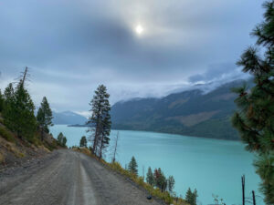
The Hurley ascends 5,500 feet, Semaphore trailhead is near the top of this elevation before it dives down into Gold Bridge. Cresting the top of the pass we hit snow, and by the time we get to the trailhead, there is a foot of it. We conference and decide to forge ahead to Tyax Lodge and beside it, our next campsite, and hope the snow melts enough for a hike tomorrow.
We pass a sign for Green Mountain and make a note to visit on our way back. Our first glimpse of Downton Lake coincides with a steep drop in elevation and another weather change. We make multiple roadside stops for pictures of the candy blue waters. Little do we know we’ll have our fill when we drive along the turquoise Carpenter Lake. The descent into Gold Bridge is ear-poppingly quick and our bodies rejoice as our wheels hit the pavement. We are in a new climate zone and the transition feels like we’ve walked through Narnia’s wardrobe. We trade evergreen cedar, fern and fir for big ponderosa pine. It feels more like the interior than the coast. Breeching a crest in the road we catch a glimpse of the saturated milky blue Carpenter Lake. It is perfectly contrasted with densely treed mountains. This view alone was worth the trip. The storm seems to have flooded the lower lake lands and caused some minor rockslides, which we dodge on our way up to the lodge.
The lodge comes into view and Joshua announces the secret itinerary he’s been planning. Lunch at the lodge and a day pass for their hot tub. It’s a special treat and even though we didn’t hike today, we enjoy it like we did.
The lodge is everything you’d imagine at a top alpine resort—roaring fire, wood beams, deep leather chairs and its very own lake. We are in shoulder season, which means we pretty much have the place to ourselves. A floatplane lands on the lake as we take our window seats. Since we’re the only patrons at the restaurant it is our duty to order a big lunch and two beers. Does food taste better with altitude? We conclude that it does.
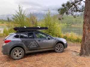
Tonight, we have a proper campfire. The lake is our backdrop, shared with only a few campers. They stop by to ask about our “seriously rad” set-up. Having admired others’ camping gear all summer, Joshua is proud to be on the receiving end of the praise, even if we don’t own it.
I sleep so soundly I’m surprised when Joshua tells me it rained hard last night. Opening my eyes, I see it’s raining inside too—hundreds of droplets hang overhead, ready to soak us with the slightest move. We discovered after our first night that the rooftop tent is the desert edition. Not exactly up to sub-alpine rainstorms. No matter, it is our last day.
I like to sneak out early in the morning and relish in the silent moment, allowing the coffee and the solitude to work together to ready me for the day, this is my meditative ritual. I am present, observing everything, snapping pictures with my eyelids and isolating sounds. I can see a duck on the lake, the ripples its body makes as it forages for food, but can I hear it? Can I hear it over the sound of the wind? I carry on observing, listening, until my coffee is finished and I’ve come to life, ready to be around people.
The sizzle of cooking bacon and the burble of the espresso maker brings Joshua out of the tent. We savour our breakfast and each other’s company. Not everyone travels well together, differences in styles can be a challenge and this is made worse when you don’t have creature comforts or separate spaces. Camping companions are important, and Joshua and I work well together. Packing up is a cinch and we are on the road again.
The weather is overcast so we take the opportunity to visit some of the “what’s that” places we passed on our way up to the lodge in hopes that the weather will clear for our hike. Mowson Pond is our first stop, it didn’t look like much as we passed last evening but exploring it now, we decide that we’d like to return and camp. The dry pine clime and lakeside camp spots are attractive, and it looks like a good spot to kayak and maybe catch a fish.
Green Mountain is our next stop. Limited information on the trail could be found while on lodge wifi. All we know is there is a sign and a fire tower at the top. More importantly, there is a dirt road that acts as the perfect testing ground for our SUV’s off-road capabilities. Low and slow is the off-roader’s mantra—low gear, slow speed. Joshua adds another—approach angles. We weave through gullies and water bridges with ease, but we don’t make it to the fire tower because we have another hike planned.
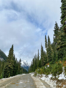
The trailhead to Semaphore lakes is easier to spot this time because there are a few vehicles parked along the road. The snow hasn’t melted but there are good tracks so wayfinding should be easier. Rain threatens but the warmer weather is melting the snow so it’s going to be slushy no matter what. We suit up in our goretex, nod to the bear sign and set off. A contingent of hikers arrives as we set off and the parked vehicles indicate that there are others on the trail ahead. It is impossible to know where on the trail they are, but there is comfort in knowing we aren’t totally alone. There is no cell coverage in this area so if anything went wrong, you’d need to rely on your partner or other hikers.
At first, the meadow is a flat muddy lake, then the trail ascends steeply along a river. We toot our air horn every now and then to deter bears. Reaching the top of the mountain’s version of the stair master, we enter a snow-covered clearing. I catch my breath and look around as I wait for Joshua. I spot two perfect paw prints on the log in front of me. One is much bigger than the other, and I imagine a bear or two hopping over this log on their way to the stream below. The prints don’t look immediately fresh, but they are definitely from today and I give the area a good scan and toot our air horn to be on the safe side. I’m not as scared as I thought I’d be, seeing evidence of bears. It could be the yearning to reach the lakes now that we’re at least halfway there or the knowledge that we’re prepared and not totally alone. Bear spray accessible, we continue.
The trail flattens out and runs across big rock slabs. Without prints in the snow or a well-worn path, it is hard to follow the trail and we wander off course once or twice before rejoining. We cross a healthy stream and plunge into some deep snow. The trees are gone now and in their place are snow-laden salal bushes and mountain heather. It is impossible to follow the exact trail due to the heavy snow, but we have a map and choose to follow prints when we can find them. We slip and slide across the slushy slope, across rivers formed by the melting snow and saying, “it’s just up here” about three or four times.
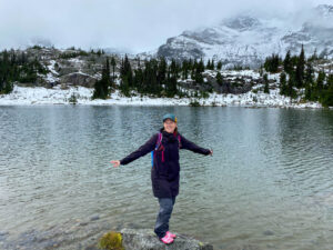
Even though the weather hasn’t cleared, the first lake is magnificent. It is obvious why this is a top-rated hike. Lunch and pictures are in order. Not long after we arrive the hiking group who was parking as we set off, emerges and tucks into their lunch too. They also saw the bear prints but they have a park ranger and a nurse in their contingent, so they are covered. The rain begins and we decide to start of our descent. We plan to come back in the summer and see all three lakes, but today it is miserable and it’s time to go.
The melting snow is so slippery now that I use my emergency poncho as a ‘crazy carpet’ sled and slide down the hillside. Joshua declines a turn. Even still, we fly down the mountain until some shouts stop us so we can listen closely. It is hard to hear but we yell back, continuing on the path toward the voices. Soon we find them, a group of five young men in sneakers, sweatpants and cotton sweaters. They look more prepared for the mall than the trail, but I don’t want to get judgey. They got lost on the rock slabs but hearing us they’ve found their way back.
They pepper us with questions about how much farther it is to the lakes and which way to go. We do our best to dissuade them from continuing, it’s still a good distance away, they are already wet, and the rain and deep snow will soak them through. They have come too far to turn around they tell us, so I unload all my hand warmers and tell them to be careful. Joshua and I talk about them and what to do for the rest of the way down.
The parking lot has only three vehicles and since we saw the other contingent of hikers arrive, we know the Dodge Charger—how on earth did that get up here—is the young mens’ car. Rooting through our belongings we find a scrap of paper, a pen and a ziplock bag so we can write a note and place it on the windshield of their car. The note has the date, time, number and description of the hikers and a plea for help if anyone finds the car still there after 7:00 p.m. That gives the hikers a few hours to get back. If they haven’t made it by then, they’ll need help.
The hiking group we met at the lake got rained out too and arrive back at the parking lot. We trade notes on the guys. They were clear on their advice to turn around, which the guys also refused. We discuss our note and what more we could do. “I’m a nurse, it’s my duty to help people, but if you want to kill yourself, I’m not responsible,” says one of the hikers. We part ways agreeing that we’ve done all that we can and hope for the best. A scan of the news for the next few days reveals no missing persons reports or stories of lost hikers—phew.
At a certain point in any hike or arduous activity the thought of food always springs to mind, and you start planning the reward you’ll get to eat. Due to the rain and cold, we ate lightly at the lake and planned to cook more at the car.
Instead of cooking in the rain, we decide to stop at our favourite Pemberton establishment, Mile One. The mouth-watering thought of hot wholesome food gets us down the mountain in record time. Mile One has a fantastic little grocery section and since we’re heading straight back to the city, I can stock up. We share a southern comfort mac n’ cheese which consists of grilled farm fresh chicken, broccolini, smoked Fraser Valley bacon on a bed of cheese noodles. Eating as we drive and basking in the euphoria of a successful trip, we discuss our highlights, the function of the car and the tent set-up and our next trip.
