
Forest fires are often spectacular to behold, raging across the landscape like a fiery beast with a fickle personality tied to the vicissitudes of wind, precipitation and the fuel in its path. They are as natural and rejuvenating to our temperate latitudes as a deep winter snowpack.
However, when people and property are in the crosshairs of a forest inferno, problems arise. Last summer, Williams Lake, British Columbia, was literally under siege by the flames. At the height of the siege in late July and August, 2017, the White Lake, Sugar Cane, Spokin Lake Road and Wildwood fires marched on Williams Lake and the surrounding communities, driven by hot winds, drought conditions and a supply of beetle-killed timber to burn. Eventually the entire town was evacuated, with most of its 11,000 inhabitants, and another 9,000 rural residents, situated on the dry plateau between the Coast Range and Cariboo Mountains dispersing to communities north and south to wait out the fires and cross their fingers that they’d have homes to return to.
Williams Lake was one of the hot spots, along with Ashcroft and several other interior communities, of a 2017 fire season that was one for the record books and eventually forced nearly 40,000 residents from homes in the crosshairs of wildly unpredictable and intense fires. By the time the flames were finally doused late last autumn, 1.2 million hectares of BC had been scorched, and the costs of fighting the fires had soared to nearly $300 million.
By all accounts, Williams Lake got hit hard. An estimated 50 percent of the forest in the surrounding Timber Supply Area was burned—a tough blow for a timber-based town. And the fires also took a deeply personal toll on residents like Deva Khurana, who was one of a handful of residents who lost their homes roughly 12 kilometres north of Williams Lake on Soda Creek Road near the Fraser River.
On July 7, Khurana was in Williams Lake when lightning crackled across the horizon. In what seemed like just minutes, towering columns of smoke rose into the sky. He raced back to his place on Soda Creek Road to start irrigating and clearing brush but was forced to leave two days later because of falling ash and an asphyxiating blanket of smoke.
When the White Lake fire, which had erupted on the bench lands east of the Fraser, leapt across the river and tore up the hillside, there was nothing that could have been done to save the home that Khurana had built with his own hands. And there is no insurance to cover the loss.
“I didn’t want to believe it at first,” Khurana tells me, adding that he is still coming to terms with losing the home into which he had poured his life savings.
In the aftermath of the 2017 fire season, the question on many minds is whether or not tales of loss like Khurana’s are a glimpse of the future? According to experts like Mike Flannigan, a professor at University of Alberta’s renewable resources faculty who has studied forest fires and fire behavior since the 1970s, the answer is an unequivocal yes.
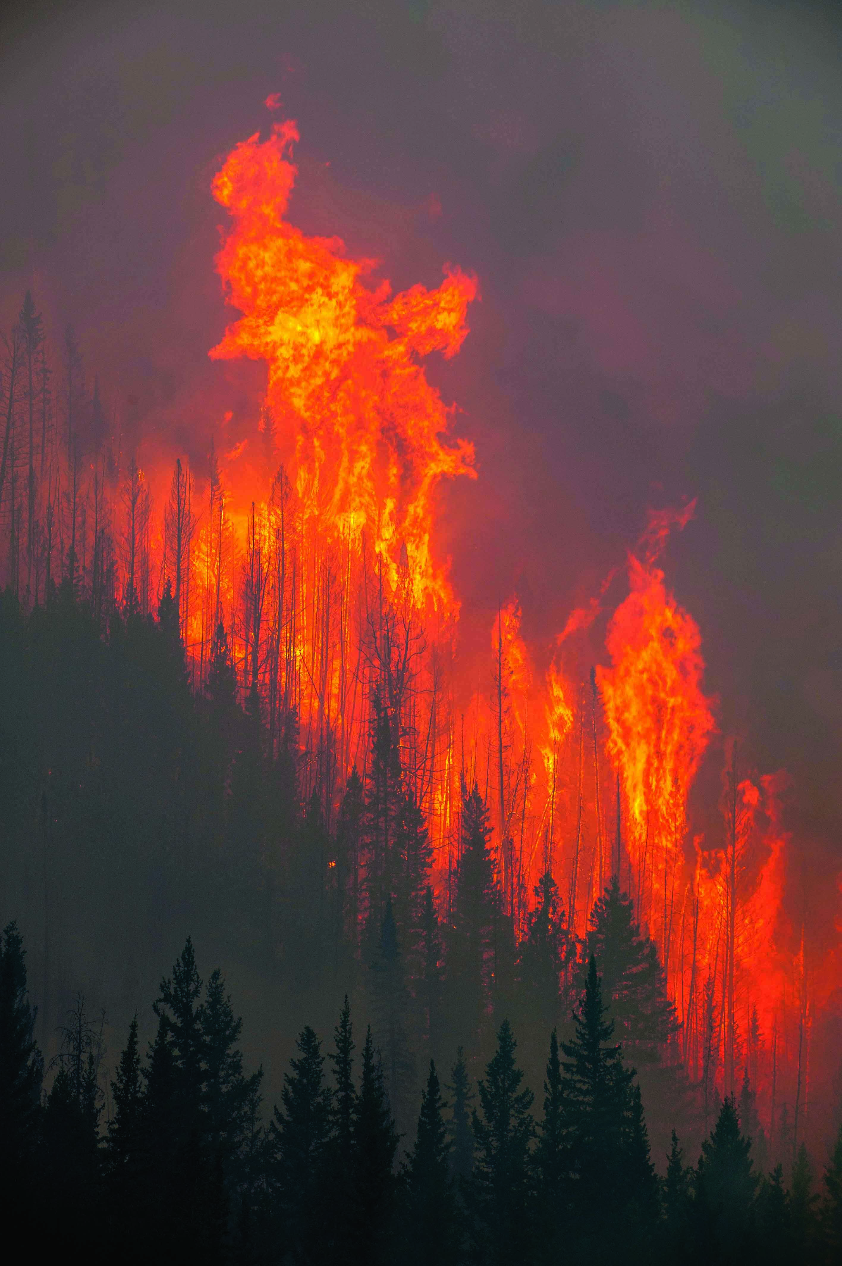 Crown fires are dangerous, as they can rip quickly between tree tops. Photo by Michael Bednar
Long before climate change became a topic du jour, Flannigan and other forest researchers preached about the impacts of global warming on forest health and forest fire frequency. The statistics are compelling. Since the late 1970s, the average annual area burned in Canada has doubled from 1.2 million hectares to roughly 2.5 million hectares. Yet against the backdrop of last summer’s destructive fire season (not to mention the one two years ago that nearly engulfed Fort McMurray in northern Alberta, or the 2003 season when the Okanagan Mountain fire razed nearly 240 Kelowna homes and destroyed many of the historic Myra Canyon trestle bridges on old Kettle Valley Railway line), it’s easy to forget that forest fires are actually beneficial to ecosystems. Burns help control the spread of insect infestations, maintain a healthy forest structure with new seedlings that sprout from the ashes and also act as natural fire breaks to impede the spread of future fires. Put people in the way of forest fires, and the narrative changes quickly.
“If the Fort McMurray Fire had occurred 100 kilometres to the east in northern Saskatchewan it would have made the local papers as a story about smoke and air quality,” Flannigan says over the phone from his office at the University of Alberta.
In 2017, Flannigan co-authored a paper published in the Environmental Research Letters that applied complex climate modeling to predict future fire frequency and behaviour in the boreal forest. Using the Global Circulation Model to forecast climate change, Flannigan and his fellow researchers came up with future fire scenarios based on low, moderate and high levels of global warming. The results were daunting. All three scenarios showed a dramatic increase in crown fires, those dangerous and difficult to control blazes that rip quickly from treetop to treetop. The authors concluded that, “not only were crown fires more likely but overall the number of days when fire intensities could exceed the capabilities of suppression resources (even large air tankers) also increased substantially…”
Fire intensity must not be confused with temperature. All forest fires burn at the same temperature, roughly between 800 and 1,100 degrees Celsius. Fire intensity is the important variable and researchers measure it in kilowatts (kW) per metre of fire line. At 2,000 kW, initial attack ground crews begin to need aerial support from helicopters or bombers to hold the fire line. At 4,000 kW, aerial resources start to struggle to contain the flames, and by the time a fire reaches an intensity of 10,000 kW, aerial assets become ineffective. In other words, a forest fire is out of control.
Flannigan remembers walking in the BC interior last summer and feeling the crackle and crunch of a tinder dry forest floor underfoot. It was like a powder keg waiting for a trigger. If you dig further into climate change impacts other sobering realities emerge pointing to a future of increased fire hazard, says Flannigan. As the climate warms, experts predict the frequency of lightning storm events to also increase. In addition, for every one-degree Celsius increase in temperature, there would need to be corresponding 15 percent increase precipitation to maintain the moisture balance in the forest. And Flannigan says that all climate models suggest that, save for a few exceptions, no regions in Canada will experience this compensating increase in rain or snowfall.
“The fact is, we are going to have to live with forest fires. We’re not going to eliminate them,” Flannigan says. “But there are things we can do.”
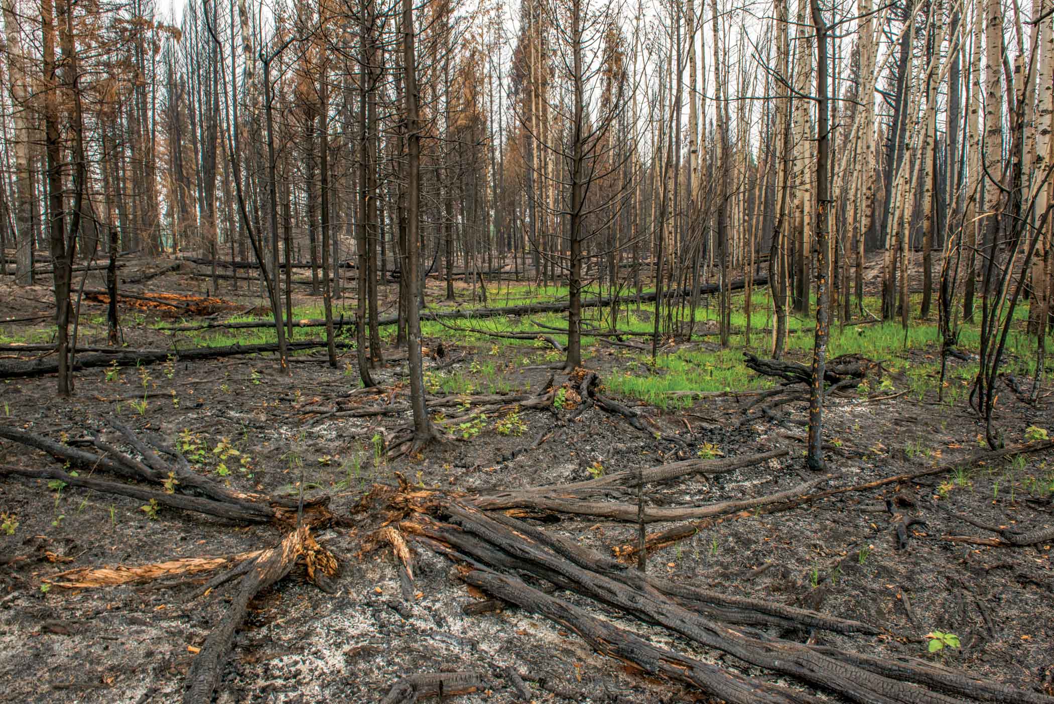 Naturally occurring fires are beneficial to a forest’s ecosystem, as they help control insects and promote a healthy forest structure through new growth. Photo by Michael Bendar
As simple and obvious as it seems, it’s helpful to consider that forest fires need three conditions to occur—the right weather, ignition and fuel. Humans can’t do anything about weather. However, human-caused ignition—such as a carelessly discarded cigarette butt, an unattended campfire, sparks from railway rolling stock or trees falling on a power line—are mostly preventable. We can also do something about reducing the fibre supply that fuels a fire; for example, the thinning of forests that interface with communities can help diminish the risk of uncontrollable crown fires.
Professional foresters like Erik Leslie, who manages the Harrop-Procter Community Forest in the West Kootenays, are applying innovative forest management practises in anticipation of a not-so-distant future when falls, winters and springs in that part of the world will be two to five degrees Celsius warmer and between 10 and 25 percent wetter, and summers will be between three and seven degrees warmer and 30 percent drier. This leads to a cascade of impacts on stream flow and hydrology due to a shrinking winter snowpack, the mix of tree species in a forest and the frequency of forest fires and insect
epidemics attacking drought-stressed trees. Strategically thinning the forest and shifting silviculture planting prescriptions toward more drought-tolerant species—for example, pine—managers can both help shore up the forest resource and protect adjacent communities from wildfires.
When it comes to fire suppression, one tactic will not change as the climate warms. That is, if we attack fires early, hard and fast, we stand a better chance of controlling them. However, there is simply not enough person-power and resources to effectively combat all forest fires, meaning fire-fighting managers will need to get much more sophisticated in how they prioritize fires and allocate finite suppression resources. In a perfect world, fires that threaten life and property get top priority. As part of its Wildland Fire Management Strategy, Ontario’s Ministry of Natural Resources uses weather modelling that incorporates wind speed and direction, temperature, precipitation and other variables to project fire behaviour two weeks in advance and help decide where and when fire-fighting assets will be deployed.
Flannigan calls the efforts last summer of BC fire fighters “heroic” at a time when resources were stretched. In the aftermath of a difficult fire season in which people lost homes and tourism operators isolated and cut off by the fires lost an entire season of revenue, there will always be critics of fire-fighting decisions made in the heat of the moment. However, Flannigan believes the fact that there was no loss of life is a testament to how effectively the BC Wildfire Service communicated an extremely volatile forest fire situation in the interior triggered largely by lightning strikes and compounded by winds and drought conditions. You don’t have to look farther than California, which was devastated by fires in Napa Valley, Sonoma County and the south, for evidence of just how deadly fires can be.
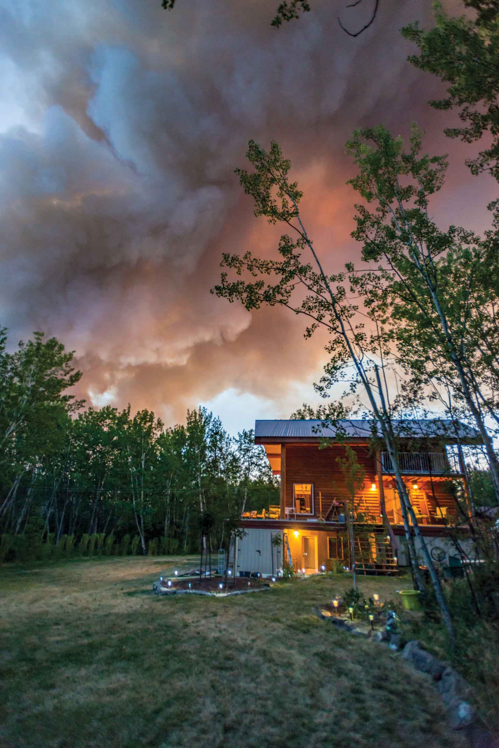 Photographer Michael Bednar shot this photo of his house moments before he was evacuated. Mercifully his property survived the fire.
Retired NRCAN forest fire researcher, Tim Lynham, says conventional fire suppression is doing its job, catching many fires at a small size and protecting special areas using fire crews and water bombers. The problem, he says, is that conventional suppression can’t save a place like Fort McMurray when the area of intense fire is so large. That’s why he believes in Canada we will increasingly choose to allow remote fires to burn in order to reduce suppression costs and focus resources where life and property are at risk.
“Fire is good for most places, just not our backyards,” Lynham says.
He believes we need to stop building houses with combustible roof tops and instead use metal, clay or some other non-combustible material. Lynham calls it the best way to protect communities, noting that houses usually ignite after burning embers land on roofs.
Climate change is introducing another natural fire hazard in the form of thawing peat bogs in the north that have been frozen for most of the past 10,000 years, and are now being increasingly ignited by lightning strikes.
“We’re adding this new source of fire that brings with it the release of nasty things like methyl mercury that was deposited in the peat during the industrial revolution,” Lynham says, referencing research conducted by University of Guelph biologist Merritt Turetsky. “And Canada, Alaska and Russia have 65 percent of the peat in the world.”
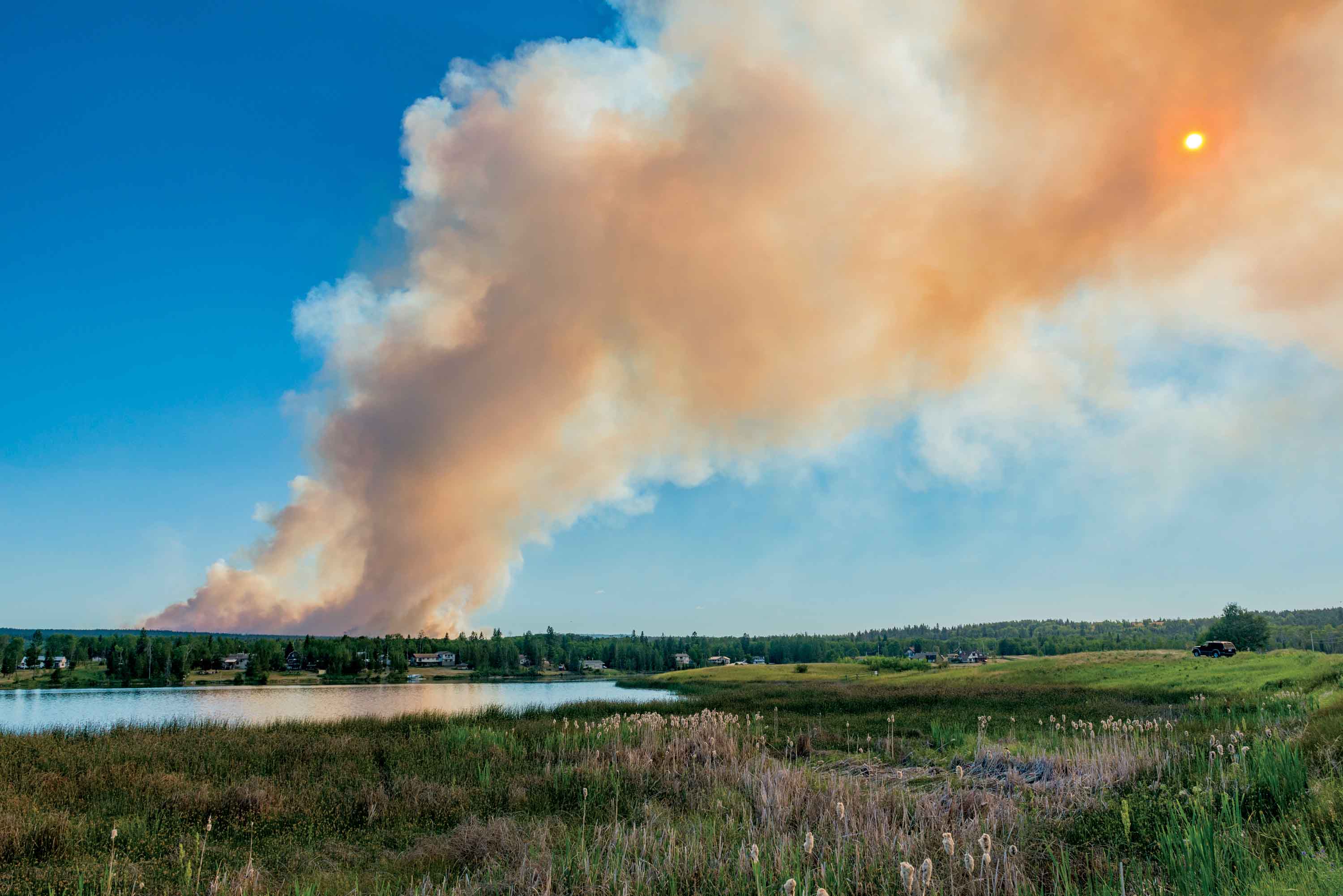 Photo by Michael Bednar
As we adapt to a future of heightened forest fire hazard, researchers at the University of British Columbia are applying new technology to better understand the impact of fires on the land base. In a project co-supported by NSERC (Natural Sciences and Engineering Research Council of Canada) and forestry analytics firm FYBR Solutions Inc., UBC remote sensing expert Nicholas Coops is leading a team of graduate students exploring the potential of using drones to document not only the extent of forest fires but the condition of timber left standing. Last fall, the research team flew a drone above a test patch of burned forest near Williams Lake. Able to cover roughly 200 hectares per day, the drone takes a continuous series of overlapping still images that Coops says provides a level of detail that far surpasses satellite imagery or aerial surveys using planes or helicopters.
“We can get a three-dimensional view of individual trees right down to branches, and the colour of the tree,” Coops says. “This can inform future decisions about things like what trees are still harvestable in a burn and the likelihood of natural regeneration.”
And this is critically important for a place like Williams Lake that witnessed a large portion of its timber supply go up in smoke last summer.
And there is also the personal human cost of forest fires that people like Deva Khurana on Soda Creek Road know all too well. This year he will return to his property and consider how to rebuild a home from the ashes.
