If there’s one thing we should all have realized from the near daily news reports of climate change phenomena—from fracturing Antarctic ice shelves to record-smashing typhoons—it’s that climate change isn’t some inchoate spectre that may or may not haunt our future. It is happening now, has been for decades, and its pervasive effects surround us, already directing our lives. Whether these make the news or not, British Columbians are very familiar with the face of a changing climate.
As much uncertainty as there is around the magnitude of change going forward, however, there’s great certainty around its inevitability. And since we humans are adaptable but information-driven organisms, the more we know the easier it is to adapt. In that spirit, I’ve scoured Canadian and BC government climate websites to assemble an atlas of climate change in BC—a helpful reminder of where we’re at and where things might be going.
What’s Happened
Government data indicates that over the past century, BC’s annual temperature has warmed an average 1.4°C (1.1°C summer/2.1°C winter). The average overnight minimum in winter has risen by 3.1°C, with 24 fewer frost-free days each year and lakes and rivers ice-free weeks earlier in the spring. From 1985 to 2000 alone, BC lost 22 cubic kilometres of ice per year from its glaciers. Although precipitation is up across the province, increased drought and larger, more intense wildfires are features of many regions. The ocean is warming and acidifying at an alarming rate and sea level has risen along most of the coast.
What’s Coming
Even under a moderate greenhouse gas emissions scenario for the foreseeable future, BC can expect warmer temperatures in all seasons—a projected additional 2.4°C average in summer and 2.9°C in winter by the year 2100. In addition, now and in coming years British Columbians can expect some or all of the following: more frequent and intense heavy-rain events; changes in growing seasons for crops and gardens; increased drought and water shortages; larger, more frequent wildfires; changes in streamflow patterns, wetland extent and lake levels; a further rise in sea level (up to a metre by 2100) and stronger storm surges; changing forest conditions; smaller snowpack; continued loss of glaciers; and increased ocean warming and acidification.
Those are the physical things we can relate to as humans because it is immediately apparent to us how they might affect our lives, commerce, communities and regions. But there are also subtler effects on the natural environment that have already taken hold and will soon affect us as well—like shifting plant and animal distributions. A BC government document that assessed the vulnerability of wildlife to climate change identified major drivers as the increased unpredictability in weather and the resources various species depend on. Those species that are pre-adapted to unpredictability—generalist species like deer, coyotes, crows, invasive bullfrogs and warmer-water fish will be able to exploit new conditions and likely benefit.
Most specialized species, however, will face challenges and stresses that will limit their ability to remain where they now live. Even if they can move to a new area, many will face atypical ecosystems caused by changed disturbance patterns, invasive species, disease outbreaks, loss of wetlands, increased water temperature, increased infant mortality and changes in the abundance and timing of appearance of prey. Most of BC’s amphibians, alpine and riparian-dependent mammals, aerial insectivores and marine birds, cold-water and anadromous fish (ocean-going adults that breed in freshwater, like salmon) are extremely sensitive to climate change, and their diminished or extirpated populations will completely restructure ecosystems.
British Columbia’s is a complex landscape, however, and because of this there will be regional variations in most climate-change related impacts. Thus, the projections specific to a given region are important for human planning.
Region by Region
Coastal BC will see continued ocean warming and acidification, with shifting ranges for marine animals—some cooler-water species tracking northward, new warmer-water species arriving. These same factors will propel the influx of invasive species that, though they may have previously been introduced to coastal waters through ship-ballast discharge, hadn’t previously established because of the North Pacific’s previously cold year-round temperatures. On the south and west coasts of Vancouver Island, for example, newly established European green crab is already impacting populations of native shellfish and crustaceans, as well as uprooting eel grass beds used as nurseries by fishes like salmon.
Disease is another concern. Sea star wasting disease (SSWD) was first spotted along the BC and Washington coasts in 2013 as it rapidly laid waste to 20 different species of sea star from Mexico to Alaska. Caused by a virus that had previously only shown isolated local effects, rising sea temperatures somehow suddenly made sea stars more vulnerable, with a much higher mortality rate than in traditionally cooler water. Sunflower stars, which control sea urchin populations, were hit particularly hard; absent their primary predator, urchins multiplied along the coast and razed critical kelp forests.
Of course, there’s more. In a first published study of newly discovered seamounts off the coast of Vancouver Island, scientists reported that many of the species they were observing for the first time were already facing extinction because of rising acidification and plunging oxygen levels. And a UBC study has warned of impacts to aquaculture, projecting a loss of 60 to 84 percent of suitable areas for Atlantic salmon farming by 2050. While this may be good news for opponents of the controversial industry, warming water temperatures that drop oxygen levels and curb fish growth will also boost aquaculture-related diseases and parasitic infections already impacting native wild salmon.
For salmon, climate change effects lurk on every horizon. Ocean prey is shifting, water temperatures are affecting growth, and low-water in ancestral spawning streams due to drought is limiting returns. The diminishing salmon stocks responsible for photos of emaciated grizzlies and killer whales that make the social-media rounds each summer are increasingly exacerbated by “the blob,” a huge patch of warmer-than-normal water in the North Pacific that first appeared in 2013, lasted through 2015, and after a two-year hiatus made a return in 2018.
In addition to coping with much of the above, Victoria and southern Vancouver Island can expect further rising sea levels, more storms, wetter winters, drier summers and increasing expansion of terrestrial invasive species of plants and animals adapted to milder climates.
Vancouver and the Lower Mainland will suffer increasingly variable weather that includes increasing frequency of storms, increasing strength of storms with accompanying damage and risk to life and infrastructure, and increasing summer drought with wildfires and water shortages followed by severe autumn rain events. With rising temperatures also come more intangible issues like soaring air-conditioning costs, worsening smog and summer wildfire smoke with their associated health problems and invasive pests threatening both forests and agriculture.
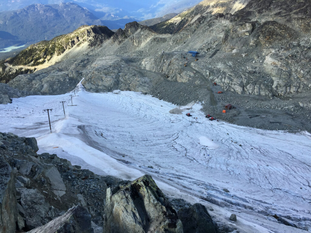
The glacier melt apparent throughout all of British Columbia’s Mountain Ranges will accelerate. Summer glacier melt in some places has been measured at six centimetres a day, and this past July, Whistler Blackcomb had to remove the 33-year-old Horstman T-bar because glacier melt had rendered it inoperable. Another issue in BC’s steep terrain is that as glaciers retreat, they reveal naturally unstable slopes that present serious human hazards. Combined with higher winter rainfall and spring temperatures, destabilized slopes increase the risk of natural disasters like debris flows and large-scale landslides. The Mt. Meager landslide in 2010, which sent 53 million cubic metres of debris into the Lillooet River Valley, was the largest in Canadian history. Similar climate-driven slope destabilization triggered the massive collapse of Joffre Peak in 2019 that came within a few hundred metres of Highway 99. In addition to landslide hazards, melting glaciers in the Interior ranges are lowering water tables, contributing to drought and wildfires that pour more carbon into the atmosphere in a positive feedback cycle.
In the Okanagan and other agricultural areas, insect phenology (time of emergence) is affecting crops. As an example, a few years ago cherry growers sprayed their annual insect control at the prescribed time only to discover that because of a warming climate they’d missed their target: the fruit flies they were hoping to circumvent had emerged two weeks earlier, hammering the crops. Such shifts also affect biological controls like insectivorous birds that time their migrations through areas to coincide with insect emergence.
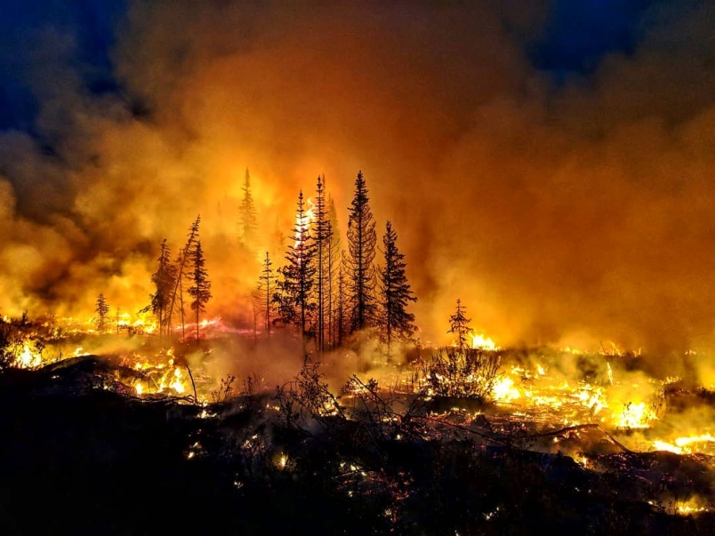
The Cariboo-Chilcotin is seeing generally increasing temperatures and drought, whose most obvious manifestation was the record-breaking, treasury-draining wildfires of 2017 and 2018. Prior to this, milder winter weather over decades had fostered a severe, widespread infestation of mountain pine beetle that devastated the region’s forest industry. Over 18 million hectares of pine forest in the Central Interior have been affected since the late 1990s. In addition, the lifeblood waters of the Fraser River, which deliver salmon hundreds of kilometres inland from the Pacific to all the watersheds of this region, is now warmer than ever, greatly affecting salmon returns that are already under pressure from oceanic changes.
Like all of Canada’s northern reaches, Northern BC is experiencing the province’s highest rate of warming (1.6˚C to 2.0˚C over the past century). But this isn’t the good thing it might at first seem to folks living there, as it’s also bringing increased precipitation (Terrace just had its most miserable summer in memory). Winter weather and recreation patterns have been affected for a while: the change to average freezing levels (now some 500 metres higher) in the north since the 1980s is apparent in the historic loss of low-altitude ski areas in Terrace (Kitsumkalum), Kitimat (Hospital Hill), and Prince Rupert (Mount Hay). In addition, loss of alpine permafrost across this vast region, resulting in the release of carbon dioxide and methane, feeds into the positive feedback loop of a warming climate.
The Future
The climate change currently underway cannot be stopped, and we are all incrementally adapting our lives to it. However, given that we know what’s happening and why, we also know what to do to limit or slow it down. It’s up to all of us to make the personal and political choices now to ensure that future generations have a brighter future ahead.
