


10 British Columbia Ghost Towns Forgotten By Time

Ghost towns are eerie, spine-tingling attractions to explore. Whether abroad or in our own backyard, something about abandonment both scares and fascinates us. With a pioneering past, British Columbia’s boom and bust towns have left us with more than a few (mostly) abandoned ghost towns.
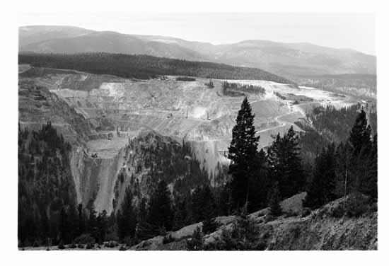
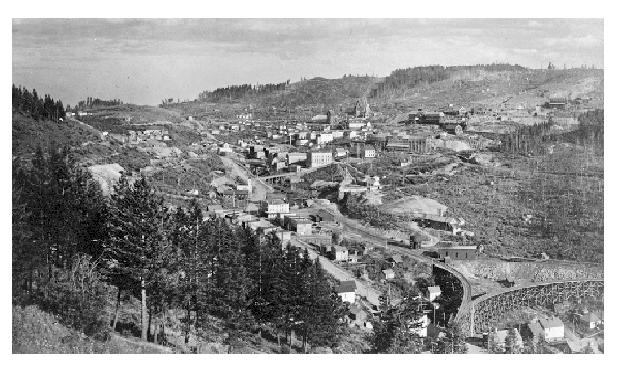
1. Copper Mountain
 Archibald, P. Vancouver Public Library, Special Collections Historical Photographs
Location: 49.325000 degrees north, 120.53889 degrees west
Copper Mountain was an important copper-mining company town in the Similkameen Country of B.C.’s southern interior, just south of Princeton.
In 1884, trapper James Jameson discovered copper ore while he was out hunting deer. This discovery led to miners flooding the area, giving rise to the town of Copper Mountain. The first camps located in the area were “Volcanic” Brown’s Camp and E. Voight’s Camp. These two camps merged to form the Granby Company’s Copper Mountain operation. Copper Mountain mining operation lasted over half a century, but falling copper prices led to a permanent shut down in 1958 and the town was abandoned shortly after.
2. Blakeburn
Location: 49.48167 degrees north, 120.74028 degrees west
Blakeburn, also known as the Blakeburn Site, is an abandoned former coal mine and coal-mining town. It sits across the Tulameen River from the surviving coal-mining hamlet in the area, Coalmont, which was the railhead for the Blakeburn Mine Railway and connected it to Kettle Valley Railway.
The town was named around 1923 for, and by, the president of Coalmont Collieries Ltd., William John “Blake” Wilson, with his employer in Vancouver, Patrick Burns of P. Burns & Co. meat packers and dealers, being the vice president and other major shareholder.
3. Bralorne and Bradian
 By Shaundd (Own work) CC BY-SA 3.0 via Wikimedia Commons
Location: 50.76667 degrees north, 122.81667 degrees west
Bralorne is a historic underground gold mining community in the Bridge River District, about 80 miles west of Lillooet.
Gold has been the central element in the area’s history going back to the 1858 to 1860 Fraser River Gold Rush. Miners flocked to the Cayoosh and Bridge River areas looking for deposits and they found it in the Bridge River area. Though called the Bridge River Gold Rush, the early period saw only 40 residents documented on the 1890 census.
Over the years, the Bralorne Mine and the other Bridge River mines were a steady fixture in the gold mining industry. But it wasn’t until the Great Depression that the mines really took off, when men and investment ramped up production. The district was one of the few bright lights in the B.C. economy during the Depression – in a seven-year period in the 1930s, the mines of the Bridge River produced $370 million in gold.
In 1931, Austin C. Taylor and associates acquired Bralorne property and financed construction of a 100-ton mill. The Bralorne Mine operated from March 1932 until 1971. In that time, three million ounces of gold were refined. From this wealth came a complete town, with schools, churches, a post office, houses, recreation halls and hunting lodges. The mines also needed support buildings, including powerhouses, boiler houses, blacksmith shops, machine shops and so on. Over 100 miles of underground tunnels were dug in the years of operation.
For many years after the mines were shut down, Bralorne sat abandoned and forgotten. But since 2002, rising gold prices have led to new exploration of the area and plans for reopening the Bralorne Mine and nearby Pioneer Mine.
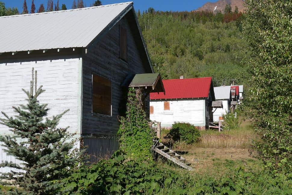
In 2014, a realtor put Bralorne’s “third townsite,” known as Bradian, up for sale for $1 million. It’s a ghost town with about 20 dwellings, last occupied in the 1970s.
4. Granby
 Frank, Leonard, Vancouver Public Library Special Collections Historical Photographs
Location: 49.050 degrees north, 123.883 degrees west
The settlement known as Granby was formerly located south of Nanaimo, on Vancouver Island. It was a planned industrial town established by the Granby Consolidated Mining, Smelting and Power Company in 1918 to exploit the Douglas coal seam. The company built a model town that included 50 houses of various sizes with modern water, power and sewer systems, on paved, tree-lined streets with sidewalks and boulevards. The town, which covered 100 acres, also had a department store and a theatre.
In 1932, the Granby mine ceased operation because the coal seam gave out, as well as the rising popularity of oil, the dangerous conditions of the mine and the Depression. In March 1936, what remained of the town was auctioned off and most of it removed.
The site is now the current location of Cassidy, a small rural community with a population just greater than one thousand residents.
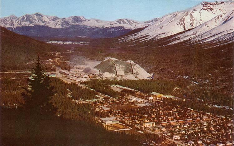
5. Cassiar
 http://freepages.history.rootsweb.ancestry.com/~cdobie/cassiar.htm
Location: 59°17′20″N 129°50′45″W
Cassiar was a small, company-owned, asbestos mining town located in the Cassiar Mountains of northern B.C., north of Dease Lake. After 40 years of operations, starting in 1952, the mine was unexpectedly forced to close in 1992. Most of the contents of the town, including a few houses, were sold off and trucked away. Most of the houses, however, were bulldozed and burned.
The mill was briefly reactivated in 1999 by Cassiar Chrysotile Inc., which had a reclamation permit to clean up the site. About 11,000 tons of asbestos was exported before the mill burned down on Christmas Day in 2000.
The town, which had a population of 1,500 in its heyday, had two schools, two churches, a small hospital, a theatre, a swimming pool, a recreation centre and a hockey rink. The four apartment blocks at the east end of the town are operational for ongoing site reclamation work.
6. Clayburn
Location: 49.083 degrees north, 122.267 degrees west
Clayburn is located at the foot of the Sumas Mountain in Abbotsford and was designated for conservation as a Heritage Site in 1996. Clayburn was the first company town in B.C., built by the Clayburn Company to provide employee housing and services. It supported three stores, a bank, a school and a church.
The discovery of high-grade clay throughout Sumas Mountain, and the demand for bricks, brought Clayburn into being. The village and the brick plant were built more than a century ago, in 1905. Because of fall off in demand, the brick plant, after operating for a quarter of a century, was dismantled in 1931.
Some of the original Clayburn structures still stand today and are part of the heritage site.
7. Fort Shepherd
Location: Click here.
Fort Shepherd is the site of a former Hudson’s Bay Company fort, located in the West Kootenay region. The fort was situated on the west side of the Columbia River, across from the mouth of the Pend Oreille River, southwest of Trail.
It was originally called Fort Pend Oreille, after the river. In 1859, the post was renamed in honour of their company governor, who had died that year.
The Oregon Boundary Treaty of 1846 had set the border at 49 degrees north latitude. After 10 years of operating Fort Colvile on U.S. soil, the Hudson’s Bay Company, feeling the pain of US taxes, decided to relocate to Canada. Angus MacDonald established Fort Pend Oreille and he thought this location was just north of the border, but could not be sure until it was surveyed in 1860. The company had planned to close Fort Colvile. But, after discovering that the gravely terrain at the new post was not conducive to agriculture, they continued to operate the southern fort for another 15 years, just to produce the vegetables and hay they needed up north.
Fort Pend Oreille was comprised of several log buildings on the left bank of a tiny creek, where the ground was wider upstream from the Pend Oreille. The buildings included a store, two warehouses, barracks for employees and a cabin to serve as quarters for the factor and his officers. They were all constructed of squared, hand-hewn logs, well-notched and tightly fitted at the corners. The buildings that were occupied had double-hung glass windows, stone chimneys and were neatly arranged around an open area, much like a parade ground at a military fort. The Americans referred to the company by its initials, HBC, which, they mockingly said, stood for “Here Before Christ.”
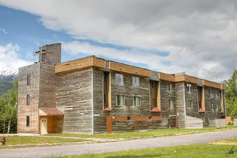
8. Kitsault
 With Permission of Soren Hedberg https://www.flickr.com/photos/sorenhedberg/
Location: 55.45694 degrees north, 129.47667 degrees west
Kitsault is an unincorporated settlement on the north coast of B.C., at the head of Alice Arm, Observatory Inlet and at the mouth of the Kitsault River.
Mining came to the remote valley with the Dolly Varden mine in 1918. Much of the area had been explored for minerals, as Anyox and Stewart had mining booms. Alfred Taylor started the mine with the help of Chicago money. Bunkhouses, stores and a 10-mile-long railway were built to access the silver ore. The mine operated for only three years until it was held up in litigation. Taylor eventually won the mine and he went on to build the Lions Gate Bridge.
The later town of Kitsault was established in 1979 as the home community to a molybdenum mine run by the Phelps Dodge corporation of the US. The community was designed for 1,200 residents and included a shopping mall, restaurant, swimming pool and bowling alley. In 1982, however, prices for molybdenum crashed and the entire community was evacuated after just 18 months of residence.
In 2004, Indian-American businessman Krishnan Suthanthiran bought the ghost town for $5.7 million.
In an effort to revitalize the ghost town, Kitsault has been proposed as a location for a liquefied natural gas (LNG) terminal site for the export of natural gas from northwestern B.C. LNG pipeline routing to Kitsault has been proposed.
9. Phoenix
 “Phoenix, British Columbia” by Unknown – British Columbia Archives, Reference #B-06813Retrieved from [1]. Licensed under Public Domain via Wikimedia Commons
Location: 49.100 degrees north, 118.583 degrees west
Phoenix is a ghost town in the Boundary Country of B.C., 11 kilometres east of Greenwood. Once called the highest city in Canada by its citizens (4,633 feet above sea level) it was a booming copper mining community from the late 1890s until 1919. In its heyday, it was home to 1,000 citizens and had an opera house, 20 hotels, a brewery and its own city hall. Phoenix’s magistrate, Judge Willie Williams, who served there from 1897 until 1913, became famous for his booming declaration, “I am the highest judge, in the highest court, in the highest city in Canada.”
In 1911, Phoenix’s hockey team won the provincial championship and asked for the right to compete for the Stanley Cup, but it was too late to qualify.
The Granby Consolidated Mining, Smelting and Power Company operated the Phoenix Mine, a copper mine that produced 13,678,901 tons of ore before operations ceased on June 14, 1919.
When the First World War ended in 1918, the price of copper dropped dramatically and Phoenix, which was completely reliant on its one industry, began to die. When the last ore was shipped out in 1919, thousands exited soon after. Many left their homes and belongings, making Phoenix the largest ghost town Canada had ever seen.
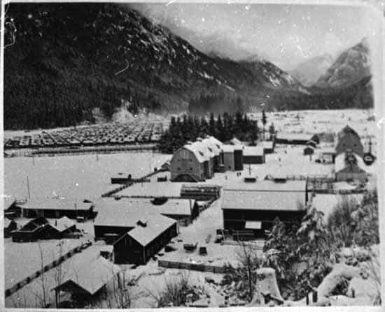
10. Tashme
 Unknown, Vancouver Public Library, Special Collections Historical Photographs
Location: 49.267 degrees north, 121.233 degrees west
Sunshine Valley, formerly named Tashme, is an unincorporated settlement and former Japanese Canadian internment camp on the Crowsnest Highway between of the town of Hope and the entrance to Manning Park in the Cascade Mountains. Located just outside the 100-mile quarantine zone from which all Japanese Canadians were removed during the Second World War, it was a large camp housing 2,400 people on the site of a former Depression-era Relief Workers’ Camp. Men housed in the camp were employed in the construction of the highway during the war. After the war, the site was sold off and has continued in existence in several different forms.
In Hope, there is a Tashme Friendship Garden in memory of the camp and its residents.

PS. Did this ghost town round up inspire you to get outside and live the adventure?
We want to send exploration inspiration, outdoors challenges and adventure gear right to your front door.
Join more than 1,000 subscribers across North America in explore magazine’s “Live the Adventure” Club.


